One Beautiful but Tough Mountain: Guided Climb of Mt. Shasta's Northeast Side, Hotlam-Bolum Ridge route, Aug. 16-18, 2013, A Trip Report
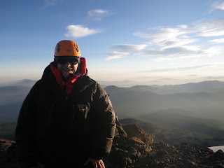 The early morning view on the ascent from around 11-11,500'.
"Exhausting," "beautiful," "breathless"--these are a few of the adjectives that come to mind after a fitful but ultimately successful summit bid last month on Mt. Shasta and climb back down. When I first heard about Shasta last spring from a guy with whom I was supposed to share a rope with on an expedition up Mt. Whitney in March, I didn't realize I was in for quite such a tough challenge. Just after finishing the climb, four of us, including one guide, who've been on Rainier rated it just as tough if not tougher than that storied mountain--given uneven, "teacupped" snow, some steeper terrain, and a lot of gnarly dirt/scree/rock sections interspersed with snow slopes that we had to move through.
"The Hotlum-Bolam Ridge is a great route for intermediate climbers in the early to mid season, but later in the season it can get more challenging as snow in some of the gullies becomes hard or icy.
Depending on your camp location ascend either directly up (if camping a bit east of the North Gate Plug) or climb diagonally to the east to reach the first snow ramp above the Hotlum Glacier. The ramp continues diagonally up and to the right above the lower rocks on the ridge. This first chute often forms icy patches within it later in the season, but they can usually be avoided. Also note the location of the crevasse on the Hotlum Glacier below this chute (if open) so that it does not cause problems on the return.
Once at the top of the first chute (named ‘The Step’) at 13000 feet there are a couple of options to reach the summit. Often climbers continue directly up a second snowfield until the ridge becomes rockier near two prominent and obvious rock towers called the Rabbit Ears. From below the Rabbit Ears most climbers traverse right a bit onto gentler terrain above the Bolam Glacier and make the climb up to the northern end of the summit pinnacle. [I believe this is how we did it. SM] Taking this option bypasses The Sharktooth (another prominent blade of rock at about 13,800 feet) on the left shortly before reaching the summit area.
Alternatively (and less frequently) climbers can stick more properly to the Hotlum-Bolam ridge from below the Rabbit Ears all the way to the summit by following class 2 rock on the ridge. Some rock of at least class 3 will normally be encountered depending on route finding and current conditions.
Descend via the climbing route. On the way down remember where the large crevasse is below the first chute. If glissading below The Step, stop and move to your left (climbers right) near the bottom often enough to be sure you are clear of the crevasse. The crevasse can be difficult to see from above."

The south side of Mt. Shasta from the hotel parking lot in Shasta City
Day Before
As I drove north from the airport in Redding, after my flight there from San Francisco, I caught my first glances from the car of the enormity of Shasta (south side), maybe 25-30 miles south of Mt. Shasta City. The mountain really towers over anything around it, with an impressive vertical rise.
Even though the south side is mostly melted out, and too dangerous to climb this late in the summer (due to rock and ice fall), it made for quite an impressive sight from the parking lot of the Best Western where I was staying on the city's edge. When I manage to retrieve the pictures I took from my phone the afternoon before and then morning of the expedition's start, I'll try to remember to post them.
Day One
We had had no prior contact via e-mail (silly REI confidentiality policies if you ask me), so I didn't know how many other climbers or guides or anything to expect. I was pleased to see, as we assembled in the parking lot behind the Fifth Season Mountain Shop in Mt. Shasta City, that it was nine climbers with me, with three guides. Their knowledge of mountaineering and of the mountain were evident from the brief orientation and then gear check that they conducted. We split up into cars for the hour and 15 minute-ish drive to the Northgate Trailhead, and I took Paul and Erica, a very nice couple from Oakland.
The last 5-6 miles of the drive were on quite gnarly dirt road, and I was glad I had switched my Hertz reservation from a car to a 4WD SUV a few weeks before the trip after reading up on a site devoted to Shasta climbing, and that they gave me a heavy-duty instead of mini-SUV. Plenty of clearance, plenty of luggage space, and plenty burly tires for all the ruts and rocks!
It was probably getting close to noon by the time we had all our gear together and boots on and hit the trail. We stopped more or less hourly for about ten minute breaks, to rehydrate and snack. This was all below-snow-line hiking, with trekking poles, up progressively steeper volcanic dirt with some stones and rocks mixed in. Somewhere between the second and third of what would be, as I recall, four stops, we exited the evergreen forest and started to get above tree line. A few wildflowers and a deer were among the few unusual sights. It wasn't till maybe a couple hours up that we got our first view of the top of the mountain and the summit--impressive!
There was no chance for a weigh-in, but I imagine that my pack, fully loaded with my gear and my share of the group gear (a cooking canister and part of our three-person tent) and two liters of water, weighed in somewhere around 45-50 pounds at the start. Thank goodness for the gear check, as I had eliminated with guides' advice maybe half a dozen items I was unsure of or where I needed to choose between two gear or apparel items. Still, that sucker felt heavier than on any training hike (where I had peaked out at 42 pounds). The one item I came to wish I'd "downsized" for maybe a more appropriate rental substitute was my big, bulky La Sportiva boots, which I'd debuted on Mt. Washington in the winter of 2011.


Altogether, I guess it took us maybe 4 1/2 hours to reach camp, after 2600' of climbing, getting in late afternoon. We had about an hour to set up camp and get together our gear for "snow school." We were probably up on the lower slopes for maybe an hour to hour and a half, going over self-arrest and a few basics of snow travel. Very basic and brief, I thought at the time comparing it in my mind to previous snow schools with REI on Rainier and EMS near Washington. But there was a method to their "madness," as they would instruct us on new skills (cramponing, rope travel, belay) as they came into play on day two. It had been a long day, and we had a short night ahead, so there was no point exhausting us.


Back at camp, it was a nice dinner consisting of a tasty soup followed by a rice concoction containing some vegetables and some slices of sausage and, I think, chicken. A few Paul Newman chocolate cookies were passed around after that. Hit the spot! (They provided the breakfasts and dinners, we provided the nutritional snack foods we'd eat during the rest of the day.)
Our tents were spread out among rocks in clearings, in an area maybe fifty yards wide and long, and maybe 20-30 yards to the side of the glacial river that served as our water source. "Just drink it from the source," the guides reassured us, there was nothing to worry about with the "glacial worms" that were known to be about and that I'd read about on a Shasta site. After going through the hassle of disinfecting my first two litters, I relented mentally and realized it made no sense to try to be a stickler--all our group water (boiled for coffee, meals, dish rinsing) came from the same place. And after all, this was the source of the town's water below, and came straight from the glacier above. So, when in Rome....! I never got sick, needless to say, and the only hassle cum adventure was walking through the rocks in the lightweight sneakers I'd brought as camp shoes and then dangling out over the stream and trying not to fall in while filling up your bottles in the mornings and evenings. And I have to admit, there was something kind of refreshing about drinking straight from the source!
Most of the group were in two-person tents, but Tony from San Francisco and Hunter from San Jose were my two mates in a three-person tent. Just enough room for our sleeping pads and bags facing the front, with a small rainfly which gave us wind protection. This meant stowing our gear on the rocks just outside the tent, which worked fine.
I probably shouldn't have taken the Diamox, a prescription prophylactic for mountain sickness my family doctor had given me for the original trip to Mt. Whitney in March. It was on the guide service's "recommended meds" list for that trip, though that list seemed to cater to higher mountains. Anyway, I'd taken Diamox before, at the Mountain RATs expedition race between 8,000 and 12,000' in Colorado and consulted doctors about taking it for my race up Izta volcano to 16.9K a few years back (one counseled against it for such a brief, intense event, another said he'd prescribed if I wanted it). The combination of its diuretic effect, the after-dinner tea and copious rehydrating from the hike up had me up five times in the night--a new record even for this middle-aged dude!--to pee. Didn't endear me to my tentmates, and I felt bad, but each time I REALLY had to go! I was also so keyed up, and couldn't get comfortable on the sleeping pad and in the bag. At most I may have gotten maybe an hour or hour and a half's shuteye.


Day Two--Summit Day: The Ascent
The guides woke us promptly at 2:00AM. We quickly got changed into our gear, went over to the mess area for some oatmeal and a cup of coffee, and put away the gear we didn't need for the day. By about 3:20AM, we were off up the mountain.
A lot of the climb runs together in my mind, as it was an intense day combining physical exertion with lots of concentration on every step and movement. You're sort of in a micro-bubble, from which you only emerge for a few moments at a time to snap a picture or take in the view or admire (or stare in awe) at what lies ahead or above or below you. It's all so intense and you're mostly very much immersed in the moment all day long.
For the majority of the day, we were in crampons, and using either trekking poles on more low-angled slopes or ice axes on steeper slopes. For all but the lower and very upper parts, we were short-roped together in teams of four, including one guide (leading on the uphill, and taking the rear on the downhill, so as to be positioned to break any of our falls or slips). A few times in both directions we were on belay (i.e., with the rope tied onto a fixed object or a climbing picket) to cross short sections with ice or other hazards, meaning our guide had set an anchor on the other side and we crossed roped together.
The basic approach was to have us stop roughly every hour to eat and hydrate. Ten minutes, pretty much on the clock! Barely time to dig out your puffer jacket (your body temperature plummets), grab and down a snack, chug a little water, reapply sunscreen and lip balm, and do any gear changes that the guide ordered for the next section. On only one rest stop on the way up did I even have time to snap a picture!
Many of the pushes ended up being closer to two hours, and it was all dictated by where we were on the mountain and if there were rocks nearby where we could rest and unrope safely. One the more challenging things for me, as a trail runner used to carrying water and having snacks handy and thus managing my energy and hydration levels carefully, was the "2 liters for the whole day" rule we were operating under. The snow wasn't safe for melting and drinking, and there wasn't time for doing that or any sense in carrying the necessary equipment, we were told. So basically we were told not to drink more than 200 millileters at each stop (fortunately, my Nalgene bottles are clearly marked), so that we could basically down one bottle going up and another going down. And we were forewarned that essentially we would be mostly dehydrated and falling behind on calories all day long.
It's in the nature of the beast, and I'd read enough about summit days in mountaineering books to know, that traveling light is the basic lay of the land. But one guy did tell me after that he snuck an extra half liter of water, and still was thirsty all day. I felt thirsty a lot of the time, and the altitude dries out your mouth and throat even if you weren't sweating constantly. At least I did make sure to pop an Endurolyte (electrolyte tablet) at pretty much every stop so as to keep any cramping at bay. The further we got up, the less of an appetite I had, though, as I had to sort of force myself to down the energy chews, trail mix, and energy bars I was carrying. They told us to aim for about 200 calories at each stop, so it was a "grazing" day with no big meals.
As we got higher toward The Step at 13,000', particularly going up the "ramp" section, the going got steeper. Our zig-zagging route became even "zaggier" as we would have to execute the duck-footing maneuver we'd practiced briefly in "snow school" on day one each time we traversed back toward the opposite side of the slope angling slowly upward--splaying boots outward and planting ice axe and then stepping over the rope (to always keep it on the downhill side) and then transferring the axe to the uphill hand. (One of the other rope teams took a steeper line, I guess because the guide figured the climbers were stronger.) It seems tedious but is actually strenuous and a little nerve-wracking (especially for those lacking in the coordination department at times on snow that is that "terraced" and uneven), as you want to do it smoothly to not interrupt the team's progress but are conscious of staying balanced. I felt very mechanical doing it and talking myself through the steps each time.
I also found myself getting fatigued in the forearm holding the ice ax, and relieved when five or so minutes later we would "turn" and head in the opposite direction, giving that arm a break. I realized at one point that our guide was digging his ax in much farther from his body (and higher up the mountain) than I, and I started trying to do this. I found this maybe better for balance but at the same time even more stressful for the arm muscles. (Guess I missed a muscle group in the all the extra gym time I put in this summer guided by a mountaineering training book.) Anyway, the basic rhythm was "plant ax, step, step, plant ax....."
Among the many other challenging elements of rope travel (let's just stick with uphill for the moment!) was following in the footsteps of a guide who must have been 6'2" or so and thus a good four inches taller. As he sort of "chopped" steps in the uneven snow (which become softer as the day heated up). But most challenging, both up and down, was keeping up with the rhythm. Go too slow, and you get a taut rope and call the attention of the guide and feel like your holding up the train. Go too fast, and you get right up on his heels (I was second of the four on the way up). Occasionally, you feel the tug of a taut rope on your harness, as the guy behind is encountering some issue or is maybe slipping a little. The guide is braking any slips before they can even get to the point of a fall or much less anyone have to go into self-arrest position. A few times I or others started to call out "falling" as that was happening. Sometimes the slips themselves have a lot to do with the tight choreography of just keeping four roped people moving together on challenging uneven terrain (angled up to 35 degrees or so at times). In other words, you get pushed and pulled a lot, which adds to the challenge of keeping stable footing on the way up. But hey, no way would I have felt safe unroped on those slopes!
I felt like I was working pretty hard but holding my own till the rest stop around 13,000'. The last 1,200' or so were a grind. A lot of it was less angled than lower down, but I think I was feeling the altitude and struggled to keep up and had a few slips or did stupid stuff like step on the rope. We went through some sections that were more talus/rock/scree, and I think I had more trouble in those than in the snow. A couple times the guide asked things like "are we still good?" which I'd heard before on Rainier from my guide. I muttered back that I was still moving and, probably not too audibly, that if I could run 100 miles I could do this (!). I knew he was just doing his job and giving me an out in case I wanted to rest somewhere while they summited, or maybe see if there were stragglers from the other teams who would cut the day short and head down with one of the three guides. My ropemates were nice enough to utter words of encouragement in a couple tough sections, and never once complained that I was holding them up, for which I'm quite grateful looking back. While they were working hard too, they clearly had more energy and were moving more easily. Oh, those 30-something rock climbers!
We removed crampons and unroped as we were on loose dirt and rocks the last 500' or so. I kept thinking we were almost there until I looked up and saw the steep switchbacks ahead. I was basically with two climbers from the other teams in our party along with one of the other guides, as my two ropemates had forged ahead along with our rope-team guide. The strain on their faces was mirrored in how I felt. Just a few hundred feet from the top, we stepped over a tiny little stream of hot volcanic "stuff" they told us not to step in as it might melt our bots. There and in a few other spots, there was a sulphuric smell that reminded you, hey, we're climbing a dormant but still active volcano! I summited about 11:20, after almost exactly eight hours. Weary but very satisfied.
I spent about half an hour on the summit. Checking out the gorgeous views, which were obscured in one direction by clouds. Snapping some pictures. Eating and drinking. And catching my breath! One of the other climbers said I needed to take a summit picture and volunteered to snap it and told me to grab an ice ax. The guides had forewarned us that our stay would be short up there. Particularly as they were concerned about clouds that had started rolling in during previous hours, and a slight chance of rain/thunderstorms in the forecast. With all of us up there plus a couple other small parties of climbers, it was the only real time there was a crowd of people during the whole expedition. And by crowd, I mean, maybe no more than 20 or so!


 Views from the summit, with me pictured second from the top
Some lower peaks are visible to the north and south, like Mt. Lassen, a volcanic peak to the south with only traces of snow left. But nothing that really stands out the way you see many other Cascades peaks from Rainier, even from lower elevations. Mostly, as far as the eye can see in either direction, it's a forested and rolling to mountainous countryside.
Now came what I knew would be the hardest part of the day for me!
Day Two: Summit Day--The Descent
Once we got through the dirt and rocks and an icy patch (blue ice) where we crossed one by one on belay, the crux of the descent was roped travel with crampons and (for the most part) trekking poles. We were sort of on a downward forced march with a lot of "slipsiding away" goin' on! Constantly going up and over the terraced snow and trying to keep pace with my two ropemates ahead of me, with the three of us taking turns slipping and falling but with the guide at the rear braking our momentum and us all stopping to regroup every time that happened. I did more often but one of the two others had his share of spills, while the third guy was a practiced skier and seemed to fare more naturally with the way your boots slid with each step on the softened afternoon sun and with his sense of balance. I felt like a fish out of water who longed to move more deliberately and in more of a zigzag line and with a crabwalk style. With precious little ski experience and all of it bad (dislocated shoulder), the out of control feeling is not a good one for me.
A sort of unplanned rest stop came at one point when one of the other guys (who had been tasked with leading us toward certain landmarks as visibility had declined with growing cloud cover) fell and we decided to just quickly eat and drink right there in the snow. From there the guide instructed us we were going to need to move more deliberately through the next section, as our fall line (i.e, from any long uncontrolled fall) was going to leave us dangerously above a crevasse that marked a bergshrund (says the Freedom of the Hills' glossary: "Giant crevasse found at the upper limit of glacier movement, formed where the moving glacier breaks away from the ice cap or snowfield above.") "No falls in this section" was the dictum, which made us all nervous and extra-careful. So we started taking lines that weren't as steep as we zig-zagged our way down. We were moving slow enough that I could abandon for a while my ineffectual efforts to use "plunge step" technique and go back to my "crabwalk" (not a technique, just how my body seems to want to stay upright). It seemed like forever, but we were maybe a half hour or more in that very vigilant mode, and despite a few slips we all managed to avoid any falls.
Then after a brief section we got down to a place for a brief rest break, and to unrope and pack up crampons and ice axes and exchange for poles. There was a gnarly scree-filled section on which I was falling back as the guide Bryan and the two other guys pushed ahead. I wasn't really able to "skate" downward on the loose rocks the way they were urging me, I think mostly because of the bulkiness of my boots. Fatigue also factored in, as I'd only had a little swig of water left and didn't have much appetite at the rest break so clearly way behind on calories. Bryan waited for me as the other guys went ahead on the last long snowfield, right below which lay camp.
"Bootskiing" is the method of choice for most for descending this less-angled slope. My skiing background basically consists of a badly dislocated shoulder, so needless to say it didn't come natural! Every time I tried that I ended up on my butt. I also wasn't having much success with the plunge step with the bulky boots and tired muscles. The only thing that half-worked was the crabwalk of winding my way down alternating sides. But I would keep trying the other methods occasionally, until I'd fall again. And get right back up. I was getting very frustrated, being so close to camp and just wanting the day's outing to be over with already1 Finally, when we were less than 100 yards from reaching the start of the trees just above camp, Bryan asked if I'd like to rope up, and we put on crampons and got through the one last more difficult section that way. I'm so grateful looking back for his patience.
I was relieved to get to camp, and pleasantly surprised that they hadn't started eating dinner, as I was the last down. Not sure if they were waiting for us, or if everyone had been chilling out and resting in their tents. But it was a tasty dinner and everyone was in very good spirits. The sort of mental haze of the effort and the day's challenges kind of gave way to a feeling of satisfaction I/we had gotten through it. In fact, everyone had summited, which is pretty rare for these guided parties. All 12 of us paying climbers!
Needless to say, I slept much better than the night before, and was dehydrated enough that I didn't have to get up to go in the night.
Day Three: The Short Descent
Up early as I couldn't sleep anymore. Got a chance to admire the gorgeous views back up to the summit and of various peaks and mountains in the distance to the north. We started packing up our gear and the tents, and had a nice breakfast. On the trail by around 8:30 or so.
Things spread out on the trail (all dirt and small stones from here, no more snow) as many seemed eager to get back to their cars, the drive back to Shasta City, and the long drives home that awaited most. I was toward the rear with two guides when I lost my balance, and sort of twisted my right knee and ankle as I landed on my pack. I really thought I'd done a number on my knee, but quickly realized as they helped me up and we got going again that the ankle was more problematic. Imagine that, of all the places to actually hurt myself, a relatively easy section with just some loose stones. Again those damn heavyweight winter boots were a contributing factor.
Anyway, I was fine to keep going and it seemed to loosen up. But I could tell this was an injury (probably an eversion sprain) that might be with me a while. (Back in NYC, like 5 days later, precautionary x-rays on both the knee and ankle were negative. I did end up missing 5-6 days of running and then having to ease back in, and wasn't really right to run trails for a couple weeks after.)
*************************************************************
All in all, this was an even more challenging climb than I had imagined. Maybe partly because the mountain was tougher than I had expected, maybe partly because a couple years had passed and my alpine skills were rusty...or maybe I'd just forgotten how hard each climb really has been for me. Compared to trail running, this is pretty far outside my comfort zone. Demanding not just stamina but a good dose of dexterity. Yet I keep getting drawn back to it, wanting to get better, wanting to keep inching a little higher, wanting to keep learning, keep the process going, the adventure continuing.
The lure of the peaks is strong! So I'll be going back soon (Mt. Whitney in March, I do believe!).
Scott B. Martin

"Exhausting," "beautiful," "breathless"--these are a few of the adjectives that come to mind after a fitful but ultimately successful summit bid last month on Mt. Shasta and climb back down. When I first heard about Shasta last spring from a guy with whom I was supposed to share a rope with on an expedition up Mt. Whitney in March, I didn't realize I was in for quite such a tough challenge. Just after finishing the climb, four of us, including one guide, who've been on Rainier rated it just as tough if not tougher than that storied mountain--given uneven, "teacupped" snow, some steeper terrain, and a lot of gnarly dirt/scree/rock sections interspersed with snow slopes that we had to move through.
This felt like a real wilderness experience compared to my few previous climbs. We were on the less-travelled, harder-to-get-to north side of the mountain, and virtually had it to ourselves. The whole three days we probably saw no more than two or three other handfuls of climbers.
Call it rust, call it age, call it awkward movement in overkill winter-style climbing boots...this mountain really kicked my rear (and left me all too frequently lying on it). But somehow I got up, resisted my rope team guide's well-intentioned queries about whether I could continue, and managed to make it up, and then hold together through a long and trying descent.
The weather was gorgeous and snow conditions good, the guiding first-rate, and the other eight paying climbers were fun and fit people from the West Coast who'd done lots of cool outdoors stuff, ranging from rock climbing to trekking in various places around the world, to, in a couple cases, some mountaineering. I have nothing but good things to say about REI Adventures and its local contractors, Shasta Mountain Guides, and in particular guides Brian, Joe, and Brandon. They taught us, cajoled us, protected us, and pushed us. Not to mention making some oh so flavorful meals for a camp at 9,500 feet! The camaraderie and chemistry on this trip were outstanding!
This trip marked a couple "firsts" for me--first mountaineering trip for about two and a half years (aka as a daddy) and first time summiting under my own power a 14er (though I've been higher on Izta in Mexico). It was both cool, and very daunting, to return to a world that I've inhabited only vicariously the past couple years, reading mountaineering books and reminiscing in my mind about my times on Mts. Washington and Rainer in years past. If you'd asked me on the way down from Shasta, I would have told you I was hanging up my mountaineering boots, that's how discouraged I was with my performance. But with a few weeks' hindsight now, I have a better sense of where I was weak and how I might improve. And even after a Shasta beating, I still find this whole totally unlikely business of pulling your body up the side of mountains that inspire awe is just too engaging and enthralling to give up on. In short, I'm hooked on mountaineering again!
The Beta
We basically followed the Hotlum-Bolam Ridge route on Shasta's glaciated north side, as described below, departing from the Northgate Trailhead. So the total climb was about 7,200', to the summit at 14,179'. Camp was at about 9,500', just below the (continuous) snowline.
Here is how summitpost.org describes our route:
Depending on your camp location ascend either directly up (if camping a bit east of the North Gate Plug) or climb diagonally to the east to reach the first snow ramp above the Hotlum Glacier. The ramp continues diagonally up and to the right above the lower rocks on the ridge. This first chute often forms icy patches within it later in the season, but they can usually be avoided. Also note the location of the crevasse on the Hotlum Glacier below this chute (if open) so that it does not cause problems on the return.
Once at the top of the first chute (named ‘The Step’) at 13000 feet there are a couple of options to reach the summit. Often climbers continue directly up a second snowfield until the ridge becomes rockier near two prominent and obvious rock towers called the Rabbit Ears. From below the Rabbit Ears most climbers traverse right a bit onto gentler terrain above the Bolam Glacier and make the climb up to the northern end of the summit pinnacle. [I believe this is how we did it. SM] Taking this option bypasses The Sharktooth (another prominent blade of rock at about 13,800 feet) on the left shortly before reaching the summit area.
Alternatively (and less frequently) climbers can stick more properly to the Hotlum-Bolam ridge from below the Rabbit Ears all the way to the summit by following class 2 rock on the ridge. Some rock of at least class 3 will normally be encountered depending on route finding and current conditions.
Descend via the climbing route. On the way down remember where the large crevasse is below the first chute. If glissading below The Step, stop and move to your left (climbers right) near the bottom often enough to be sure you are clear of the crevasse. The crevasse can be difficult to see from above."

The south side of Mt. Shasta from the hotel parking lot in Shasta City
Day Before
As I drove north from the airport in Redding, after my flight there from San Francisco, I caught my first glances from the car of the enormity of Shasta (south side), maybe 25-30 miles south of Mt. Shasta City. The mountain really towers over anything around it, with an impressive vertical rise.
Even though the south side is mostly melted out, and too dangerous to climb this late in the summer (due to rock and ice fall), it made for quite an impressive sight from the parking lot of the Best Western where I was staying on the city's edge. When I manage to retrieve the pictures I took from my phone the afternoon before and then morning of the expedition's start, I'll try to remember to post them.
Day One
We had had no prior contact via e-mail (silly REI confidentiality policies if you ask me), so I didn't know how many other climbers or guides or anything to expect. I was pleased to see, as we assembled in the parking lot behind the Fifth Season Mountain Shop in Mt. Shasta City, that it was nine climbers with me, with three guides. Their knowledge of mountaineering and of the mountain were evident from the brief orientation and then gear check that they conducted. We split up into cars for the hour and 15 minute-ish drive to the Northgate Trailhead, and I took Paul and Erica, a very nice couple from Oakland.
The last 5-6 miles of the drive were on quite gnarly dirt road, and I was glad I had switched my Hertz reservation from a car to a 4WD SUV a few weeks before the trip after reading up on a site devoted to Shasta climbing, and that they gave me a heavy-duty instead of mini-SUV. Plenty of clearance, plenty of luggage space, and plenty burly tires for all the ruts and rocks!
It was probably getting close to noon by the time we had all our gear together and boots on and hit the trail. We stopped more or less hourly for about ten minute breaks, to rehydrate and snack. This was all below-snow-line hiking, with trekking poles, up progressively steeper volcanic dirt with some stones and rocks mixed in. Somewhere between the second and third of what would be, as I recall, four stops, we exited the evergreen forest and started to get above tree line. A few wildflowers and a deer were among the few unusual sights. It wasn't till maybe a couple hours up that we got our first view of the top of the mountain and the summit--impressive!
There was no chance for a weigh-in, but I imagine that my pack, fully loaded with my gear and my share of the group gear (a cooking canister and part of our three-person tent) and two liters of water, weighed in somewhere around 45-50 pounds at the start. Thank goodness for the gear check, as I had eliminated with guides' advice maybe half a dozen items I was unsure of or where I needed to choose between two gear or apparel items. Still, that sucker felt heavier than on any training hike (where I had peaked out at 42 pounds). The one item I came to wish I'd "downsized" for maybe a more appropriate rental substitute was my big, bulky La Sportiva boots, which I'd debuted on Mt. Washington in the winter of 2011.


Assembling at the trailhead for the start of our expedition
Altogether, I guess it took us maybe 4 1/2 hours to reach camp, after 2600' of climbing, getting in late afternoon. We had about an hour to set up camp and get together our gear for "snow school." We were probably up on the lower slopes for maybe an hour to hour and a half, going over self-arrest and a few basics of snow travel. Very basic and brief, I thought at the time comparing it in my mind to previous snow schools with REI on Rainier and EMS near Washington. But there was a method to their "madness," as they would instruct us on new skills (cramponing, rope travel, belay) as they came into play on day two. It had been a long day, and we had a short night ahead, so there was no point exhausting us.

A rest stop on the way up to camp

The summit obscured in clouds as viewed from camp
Back at camp, it was a nice dinner consisting of a tasty soup followed by a rice concoction containing some vegetables and some slices of sausage and, I think, chicken. A few Paul Newman chocolate cookies were passed around after that. Hit the spot! (They provided the breakfasts and dinners, we provided the nutritional snack foods we'd eat during the rest of the day.)
Our tents were spread out among rocks in clearings, in an area maybe fifty yards wide and long, and maybe 20-30 yards to the side of the glacial river that served as our water source. "Just drink it from the source," the guides reassured us, there was nothing to worry about with the "glacial worms" that were known to be about and that I'd read about on a Shasta site. After going through the hassle of disinfecting my first two litters, I relented mentally and realized it made no sense to try to be a stickler--all our group water (boiled for coffee, meals, dish rinsing) came from the same place. And after all, this was the source of the town's water below, and came straight from the glacier above. So, when in Rome....! I never got sick, needless to say, and the only hassle cum adventure was walking through the rocks in the lightweight sneakers I'd brought as camp shoes and then dangling out over the stream and trying not to fall in while filling up your bottles in the mornings and evenings. And I have to admit, there was something kind of refreshing about drinking straight from the source!
Most of the group were in two-person tents, but Tony from San Francisco and Hunter from San Jose were my two mates in a three-person tent. Just enough room for our sleeping pads and bags facing the front, with a small rainfly which gave us wind protection. This meant stowing our gear on the rocks just outside the tent, which worked fine.
I probably shouldn't have taken the Diamox, a prescription prophylactic for mountain sickness my family doctor had given me for the original trip to Mt. Whitney in March. It was on the guide service's "recommended meds" list for that trip, though that list seemed to cater to higher mountains. Anyway, I'd taken Diamox before, at the Mountain RATs expedition race between 8,000 and 12,000' in Colorado and consulted doctors about taking it for my race up Izta volcano to 16.9K a few years back (one counseled against it for such a brief, intense event, another said he'd prescribed if I wanted it). The combination of its diuretic effect, the after-dinner tea and copious rehydrating from the hike up had me up five times in the night--a new record even for this middle-aged dude!--to pee. Didn't endear me to my tentmates, and I felt bad, but each time I REALLY had to go! I was also so keyed up, and couldn't get comfortable on the sleeping pad and in the bag. At most I may have gotten maybe an hour or hour and a half's shuteye.


Dinnertime at Camp and Early Evening Vistas
Day Two--Summit Day: The Ascent
The guides woke us promptly at 2:00AM. We quickly got changed into our gear, went over to the mess area for some oatmeal and a cup of coffee, and put away the gear we didn't need for the day. By about 3:20AM, we were off up the mountain.
A lot of the climb runs together in my mind, as it was an intense day combining physical exertion with lots of concentration on every step and movement. You're sort of in a micro-bubble, from which you only emerge for a few moments at a time to snap a picture or take in the view or admire (or stare in awe) at what lies ahead or above or below you. It's all so intense and you're mostly very much immersed in the moment all day long.
For the majority of the day, we were in crampons, and using either trekking poles on more low-angled slopes or ice axes on steeper slopes. For all but the lower and very upper parts, we were short-roped together in teams of four, including one guide (leading on the uphill, and taking the rear on the downhill, so as to be positioned to break any of our falls or slips). A few times in both directions we were on belay (i.e., with the rope tied onto a fixed object or a climbing picket) to cross short sections with ice or other hazards, meaning our guide had set an anchor on the other side and we crossed roped together.
The basic approach was to have us stop roughly every hour to eat and hydrate. Ten minutes, pretty much on the clock! Barely time to dig out your puffer jacket (your body temperature plummets), grab and down a snack, chug a little water, reapply sunscreen and lip balm, and do any gear changes that the guide ordered for the next section. On only one rest stop on the way up did I even have time to snap a picture!
Many of the pushes ended up being closer to two hours, and it was all dictated by where we were on the mountain and if there were rocks nearby where we could rest and unrope safely. One the more challenging things for me, as a trail runner used to carrying water and having snacks handy and thus managing my energy and hydration levels carefully, was the "2 liters for the whole day" rule we were operating under. The snow wasn't safe for melting and drinking, and there wasn't time for doing that or any sense in carrying the necessary equipment, we were told. So basically we were told not to drink more than 200 millileters at each stop (fortunately, my Nalgene bottles are clearly marked), so that we could basically down one bottle going up and another going down. And we were forewarned that essentially we would be mostly dehydrated and falling behind on calories all day long.
It's in the nature of the beast, and I'd read enough about summit days in mountaineering books to know, that traveling light is the basic lay of the land. But one guy did tell me after that he snuck an extra half liter of water, and still was thirsty all day. I felt thirsty a lot of the time, and the altitude dries out your mouth and throat even if you weren't sweating constantly. At least I did make sure to pop an Endurolyte (electrolyte tablet) at pretty much every stop so as to keep any cramping at bay. The further we got up, the less of an appetite I had, though, as I had to sort of force myself to down the energy chews, trail mix, and energy bars I was carrying. They told us to aim for about 200 calories at each stop, so it was a "grazing" day with no big meals.
As we got higher toward The Step at 13,000', particularly going up the "ramp" section, the going got steeper. Our zig-zagging route became even "zaggier" as we would have to execute the duck-footing maneuver we'd practiced briefly in "snow school" on day one each time we traversed back toward the opposite side of the slope angling slowly upward--splaying boots outward and planting ice axe and then stepping over the rope (to always keep it on the downhill side) and then transferring the axe to the uphill hand. (One of the other rope teams took a steeper line, I guess because the guide figured the climbers were stronger.) It seems tedious but is actually strenuous and a little nerve-wracking (especially for those lacking in the coordination department at times on snow that is that "terraced" and uneven), as you want to do it smoothly to not interrupt the team's progress but are conscious of staying balanced. I felt very mechanical doing it and talking myself through the steps each time.
I also found myself getting fatigued in the forearm holding the ice ax, and relieved when five or so minutes later we would "turn" and head in the opposite direction, giving that arm a break. I realized at one point that our guide was digging his ax in much farther from his body (and higher up the mountain) than I, and I started trying to do this. I found this maybe better for balance but at the same time even more stressful for the arm muscles. (Guess I missed a muscle group in the all the extra gym time I put in this summer guided by a mountaineering training book.) Anyway, the basic rhythm was "plant ax, step, step, plant ax....."
Among the many other challenging elements of rope travel (let's just stick with uphill for the moment!) was following in the footsteps of a guide who must have been 6'2" or so and thus a good four inches taller. As he sort of "chopped" steps in the uneven snow (which become softer as the day heated up). But most challenging, both up and down, was keeping up with the rhythm. Go too slow, and you get a taut rope and call the attention of the guide and feel like your holding up the train. Go too fast, and you get right up on his heels (I was second of the four on the way up). Occasionally, you feel the tug of a taut rope on your harness, as the guy behind is encountering some issue or is maybe slipping a little. The guide is braking any slips before they can even get to the point of a fall or much less anyone have to go into self-arrest position. A few times I or others started to call out "falling" as that was happening. Sometimes the slips themselves have a lot to do with the tight choreography of just keeping four roped people moving together on challenging uneven terrain (angled up to 35 degrees or so at times). In other words, you get pushed and pulled a lot, which adds to the challenge of keeping stable footing on the way up. But hey, no way would I have felt safe unroped on those slopes!
I felt like I was working pretty hard but holding my own till the rest stop around 13,000'. The last 1,200' or so were a grind. A lot of it was less angled than lower down, but I think I was feeling the altitude and struggled to keep up and had a few slips or did stupid stuff like step on the rope. We went through some sections that were more talus/rock/scree, and I think I had more trouble in those than in the snow. A couple times the guide asked things like "are we still good?" which I'd heard before on Rainier from my guide. I muttered back that I was still moving and, probably not too audibly, that if I could run 100 miles I could do this (!). I knew he was just doing his job and giving me an out in case I wanted to rest somewhere while they summited, or maybe see if there were stragglers from the other teams who would cut the day short and head down with one of the three guides. My ropemates were nice enough to utter words of encouragement in a couple tough sections, and never once complained that I was holding them up, for which I'm quite grateful looking back. While they were working hard too, they clearly had more energy and were moving more easily. Oh, those 30-something rock climbers!
We removed crampons and unroped as we were on loose dirt and rocks the last 500' or so. I kept thinking we were almost there until I looked up and saw the steep switchbacks ahead. I was basically with two climbers from the other teams in our party along with one of the other guides, as my two ropemates had forged ahead along with our rope-team guide. The strain on their faces was mirrored in how I felt. Just a few hundred feet from the top, we stepped over a tiny little stream of hot volcanic "stuff" they told us not to step in as it might melt our bots. There and in a few other spots, there was a sulphuric smell that reminded you, hey, we're climbing a dormant but still active volcano! I summited about 11:20, after almost exactly eight hours. Weary but very satisfied.
I spent about half an hour on the summit. Checking out the gorgeous views, which were obscured in one direction by clouds. Snapping some pictures. Eating and drinking. And catching my breath! One of the other climbers said I needed to take a summit picture and volunteered to snap it and told me to grab an ice ax. The guides had forewarned us that our stay would be short up there. Particularly as they were concerned about clouds that had started rolling in during previous hours, and a slight chance of rain/thunderstorms in the forecast. With all of us up there plus a couple other small parties of climbers, it was the only real time there was a crowd of people during the whole expedition. And by crowd, I mean, maybe no more than 20 or so!


Some lower peaks are visible to the north and south, like Mt. Lassen, a volcanic peak to the south with only traces of snow left. But nothing that really stands out the way you see many other Cascades peaks from Rainier, even from lower elevations. Mostly, as far as the eye can see in either direction, it's a forested and rolling to mountainous countryside.
Now came what I knew would be the hardest part of the day for me!
Day Two: Summit Day--The Descent
Once we got through the dirt and rocks and an icy patch (blue ice) where we crossed one by one on belay, the crux of the descent was roped travel with crampons and (for the most part) trekking poles. We were sort of on a downward forced march with a lot of "slipsiding away" goin' on! Constantly going up and over the terraced snow and trying to keep pace with my two ropemates ahead of me, with the three of us taking turns slipping and falling but with the guide at the rear braking our momentum and us all stopping to regroup every time that happened. I did more often but one of the two others had his share of spills, while the third guy was a practiced skier and seemed to fare more naturally with the way your boots slid with each step on the softened afternoon sun and with his sense of balance. I felt like a fish out of water who longed to move more deliberately and in more of a zigzag line and with a crabwalk style. With precious little ski experience and all of it bad (dislocated shoulder), the out of control feeling is not a good one for me.
A sort of unplanned rest stop came at one point when one of the other guys (who had been tasked with leading us toward certain landmarks as visibility had declined with growing cloud cover) fell and we decided to just quickly eat and drink right there in the snow. From there the guide instructed us we were going to need to move more deliberately through the next section, as our fall line (i.e, from any long uncontrolled fall) was going to leave us dangerously above a crevasse that marked a bergshrund (says the Freedom of the Hills' glossary: "Giant crevasse found at the upper limit of glacier movement, formed where the moving glacier breaks away from the ice cap or snowfield above.") "No falls in this section" was the dictum, which made us all nervous and extra-careful. So we started taking lines that weren't as steep as we zig-zagged our way down. We were moving slow enough that I could abandon for a while my ineffectual efforts to use "plunge step" technique and go back to my "crabwalk" (not a technique, just how my body seems to want to stay upright). It seemed like forever, but we were maybe a half hour or more in that very vigilant mode, and despite a few slips we all managed to avoid any falls.
Then after a brief section we got down to a place for a brief rest break, and to unrope and pack up crampons and ice axes and exchange for poles. There was a gnarly scree-filled section on which I was falling back as the guide Bryan and the two other guys pushed ahead. I wasn't really able to "skate" downward on the loose rocks the way they were urging me, I think mostly because of the bulkiness of my boots. Fatigue also factored in, as I'd only had a little swig of water left and didn't have much appetite at the rest break so clearly way behind on calories. Bryan waited for me as the other guys went ahead on the last long snowfield, right below which lay camp.
"Bootskiing" is the method of choice for most for descending this less-angled slope. My skiing background basically consists of a badly dislocated shoulder, so needless to say it didn't come natural! Every time I tried that I ended up on my butt. I also wasn't having much success with the plunge step with the bulky boots and tired muscles. The only thing that half-worked was the crabwalk of winding my way down alternating sides. But I would keep trying the other methods occasionally, until I'd fall again. And get right back up. I was getting very frustrated, being so close to camp and just wanting the day's outing to be over with already1 Finally, when we were less than 100 yards from reaching the start of the trees just above camp, Bryan asked if I'd like to rope up, and we put on crampons and got through the one last more difficult section that way. I'm so grateful looking back for his patience.
I was relieved to get to camp, and pleasantly surprised that they hadn't started eating dinner, as I was the last down. Not sure if they were waiting for us, or if everyone had been chilling out and resting in their tents. But it was a tasty dinner and everyone was in very good spirits. The sort of mental haze of the effort and the day's challenges kind of gave way to a feeling of satisfaction I/we had gotten through it. In fact, everyone had summited, which is pretty rare for these guided parties. All 12 of us paying climbers!
Needless to say, I slept much better than the night before, and was dehydrated enough that I didn't have to get up to go in the night.
Day Three: The Short Descent
Up early as I couldn't sleep anymore. Got a chance to admire the gorgeous views back up to the summit and of various peaks and mountains in the distance to the north. We started packing up our gear and the tents, and had a nice breakfast. On the trail by around 8:30 or so.
Things spread out on the trail (all dirt and small stones from here, no more snow) as many seemed eager to get back to their cars, the drive back to Shasta City, and the long drives home that awaited most. I was toward the rear with two guides when I lost my balance, and sort of twisted my right knee and ankle as I landed on my pack. I really thought I'd done a number on my knee, but quickly realized as they helped me up and we got going again that the ankle was more problematic. Imagine that, of all the places to actually hurt myself, a relatively easy section with just some loose stones. Again those damn heavyweight winter boots were a contributing factor.
Anyway, I was fine to keep going and it seemed to loosen up. But I could tell this was an injury (probably an eversion sprain) that might be with me a while. (Back in NYC, like 5 days later, precautionary x-rays on both the knee and ankle were negative. I did end up missing 5-6 days of running and then having to ease back in, and wasn't really right to run trails for a couple weeks after.)
*************************************************************
All in all, this was an even more challenging climb than I had imagined. Maybe partly because the mountain was tougher than I had expected, maybe partly because a couple years had passed and my alpine skills were rusty...or maybe I'd just forgotten how hard each climb really has been for me. Compared to trail running, this is pretty far outside my comfort zone. Demanding not just stamina but a good dose of dexterity. Yet I keep getting drawn back to it, wanting to get better, wanting to keep inching a little higher, wanting to keep learning, keep the process going, the adventure continuing.
The lure of the peaks is strong! So I'll be going back soon (Mt. Whitney in March, I do believe!).
.jpg)
Comments